
Page 6 - Index
P. 6
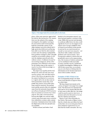
Figure 2. The image tracks the accurate path of a fire truck.

                                             plane, of the same operator, approached   landed at the destination airport), our
                                             the hold for the intersection. For reasons   team had put together a synopsis of the
                                             that were the subject of the ensuing   event. While this exercise was intended
                                             investigation, the airplane waiting at   to sooth my ruffled brow, the data could
                                             the intersection hold moved past the   equally be of use to an investigator at an
                                             hold line toward the runway as the   airport when trying to establish what
                                             other airplane started its takeoff roll. A   occurred in an incident on the ground.
                                             high-speed abort followed; and having   It need not be an event between two
                                             been able to see that the other started   aircraft as more and more airports—not
                                             to move onto the runway, I adopted the   only those with a surface movement
                                             brace position waiting for what I thought  guidance and control system—have
                                             would be an inevitable collision. In the   transponders added to vehicles that are
                                             end, the airplanes passed each other   permitted to move in the maneuvering
                                             without contact. A sidenote: Except for   area. The location of vehicles and aircraft
                                             my traveling companion, all the other   can be established with reasonable
                                             passengers were oblivious to the reason   accuracy, and this may be a useful aid
                                             for the sudden stop on the runway. It   to incident investigation. Making use of
                                             may be true that a little knowledge is a   ADS-B data means that, as an airport,
                                             dangerous thing.                     you are not reliant on third parties for
                                               The airport was equally uninformed.   information on the location and move-
                                             Which exit, which aircraft, how close   ment of the incident vehicles.
                                             was the contact, who said what and to
                                             whom? All of these are questions that   Examples of ADS-B Data in Use
                                             the airport had limited or no answers   The accompanying images are taken
                                             to. A quick call to the air data team at   from actual datasets at airports where
                                             To70 postincident meant that, from   we collect data.
                                             public data sources, most of the ques-  The loop-shaped movement on the
                                             tions could be answered. The ground   runway in Figure 1 (see page 5) is a single
                                             track and the speeds of the two airplanes   event. This illustrates how detailed the
                                             came from the automatic dependent    data can be. Let us assume that the driv-
                                             surveillance-broadcast (ADS-B) antenna   er had cause to drive like this. The image
                                             that we maintain at several of our client   could be used to assist in interviews—a
                                             airports. The radio communications   memory aid to the discussion or to con-
                                             between the flight crew and air traffic   firm the vehicle’s movements.
                                             control came from open-source websites   Figures 2 and 3 show the path of a
                                             that redistribute aviation radio commu-  fire vehicle. The tracks in Figure 2 show
                                             nications. Communications from inside   that the vehicle does not follow the hard
                                             the flight decks of the two aircraft were   surface but cuts across the grass; there is
                                             not available.                       data validation required here to con-
                                               Within an hour (and before I had   firm that the track is accurate. The very

        6  •  January-March 2022 ISASI Forum