
Page 6 - Forum-2020-JulyToSeptember
P. 6
part of the flight is unknown because
there was a lack of data to be able to
determine the precise tracking of the
aircraft during the steep descending turn.
However, it is likely that there was a tight-
ening turn to the right given the trend
suggested in the data.
Investigators were unable to identify
and fully understand the underlying
causal and contributory factors. The in-
vestigation’s sole finding as to cause and
contributing factors was that the aircraft
departed controlled flight, for reasons
that could not be determined, and collid-
ed with terrain.
The relevant finding in the TSB acci-
dent report as to risk was that, if flight
data, voice, and video recordings are not
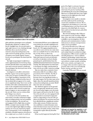
Multilateration surveillance data of the accident. available to an investigation, the iden-
tification and communication of safety
pilot and three passengers were on board. be determined if there was an abnormal deficiencies to advance transportation
Shortly after departure, at about 2135 event before the aircraft’s rapid descent. safety may be precluded.
Pacific daylight time, the aircraft made a Although there were no recordings on For several decades now, FDRs and
tight right turn as it was climbing through board, the TSB engineering laboratory CVRs have been conceived, designed,
8,600 feet above sea level and then was able to work with the raw radar data and installed in order to record flight
entered a steep descending turn to the that was available from two radar sites in and cockpit data for accident investiga-
right until it struck the ground. All of the the vicinity of the accident site. tion purposes. FDRs record a number of
occupants were fatally injured. Impact The goal was to determine the aircraft’s aircraft parameters—such as altitude,
forces and a postimpact fire destroyed the flight path (ground track and altitude) airspeed, and heading—many times per
aircraft. as well as to calculate vertical velocity, second. CVRs record radio transmissions
The high-energy impact resulted in a ground speed, and deviation from the and ambient cockpit sounds, including
crater approximately two feet deep. Frag- published standard instrument departure pilot voices, alarms, and engine nois-
mented aircraft debris was projected into routing. This information was then used es. Image/video recorders capture and
trees and scattered around a small area. to document the flight, synchronized in provide video of the crew immediately
The postimpact fire destroyed most of the time with the air traffic control recording. before, during, and after an event.
aircraft structure. This raw radar data consisted of mul- Currently, FDRs and CVRs are consid-
Investigators were able to determine tilateration (MLAT) surveillance data
that the engines were producing power provided by NAV CANADA. The MLAT
at the time of impact and that there was data were inaccurate for the takeoff
no in-flight breakup or separation of the because there was significant scatter in
wings. Weather conditions at the time of the radar targets. For the latter part of the
the accident did not appear to be condu- flight, when the aircraft transitioned into
cive to significant icing. There were no dif- a steep descending turn, accurate MLAT
ficulties with radio communications, and data were also not available.
none of the communications between the The climbout segment of the ground
pilot and air traffic control revealed any track was generally smooth and consist-
sense of urgency or any anomalies with ent. Several radar targets were obviously
the aircraft. There was no evidence that false targets (off track) in the MLAT data.
pilot fatigue was a factor. Since the aircraft was only equipped with
In contrast to the first accident, the a single bottom-mounted transponder
information normally contained in flight antenna, depending on the aircraft’s po-
data recording systems was not available sition and attitude, the antenna may have
to this investigation. The aircraft was been shielded from a significant number
not equipped with a flight data recorder of the radar sensors. Position inaccura-
(FDR), a cockpit voice recorder (CVR), cies could have occurred because some
or any other lightweight flight recording of the blocked sensors may have detected
system, nor were any required by regula- reflections off nearby terrain, rather than Although not required by regulation, a cell
tion. Consequently, it was a challenge to transponder replies directly from the phone that had GPS, voice recording, and
establish a detailed sequence of actions in aircraft. accelerometer capabilities was attached to
the cockpit, and, as a result, it could not What exactly happened during the final the Mitsubishi aircraft’s radio.
6 • July-September 2020 ISASI Forum