
Page 23 - Index
P. 23
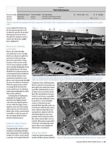
Figure 4: Spreadsheet updated with basic component information. Note: Included data is exemplar in nature and not indicative of the subject
        event.
        were marked for follow-up
        by the systems group to try
        to identify specific structural
        damage and narrow down
        the specific airplane section
        where the structure might
        have originated.


        Naming and Orienting
        Landmarks
        Due to its wide distribu-
        tion and ease of use, Google
        Earth was chosen to plot the
        locations of the wreckage
        that were identified. Using
        location information in the
        text of news reports and the
        most notable landmarks from
        the initial photos, the team
        identified an impact point in
        a recreational area northwest
        of the Tehran airport near
        residential apartment com-  Figure 5: Example photo with both airplane components and landmarks. Note the vertical concrete
        plexes and continuing through   walls and water tower in the distance. Source: CC BY Fars News Agency via Wikimedia Commons
        an area of walled-in orchards.   5 business days. Following the
        With the general area of the   first two phases, the group was
        wreckage field defined, the   then split into subteams made
        team could move to labeling   up of the individual focus are-
        particular landmarks in other   as that were previously identi-
        areas of the photos.        fied. The spreadsheet was pro-
          Labeling these landmarks   vided to each team in parallel,
        explicitly in Google Earth   and each took additional time
        proved to be highly benefi-  to perform a more detailed
        cial when sharing the photo   review of the photos and
        review with the larger inves-  provide their specific notes on
        tigative team and discussing   each photo individually. Notes
        observations over the phone.   were collected directly in the
        Both sides of the conversation   spreadsheet, aligned with the
        were able to refer to areas of   individual photos and com-
        the wreckage field by these   ponent entries that provided
        predetermined names.
                                    the observations that were re-
                                    corded. This process provided
        Follow-On Work: Deeper      a basis for recording the data
        Engineering Review          upon which each significant
        Completing the initial review   observation was based.
        of photos, including identify-
        ing components and marking   Virtual Field Notes
        images for follow up by specif-  Using the observations gath-
        ic groups, took approximately   ered in all three phases and the   Figure 6: Wreckage map with landmarks labeled. Source: Google Earth

                                                                                    January-March 2022 ISASI Forum  •  23