Page 10 - Forum-2021-JanToMarch
P. 10

reconstructed distance to the object:


                                                                             The Evaluation Case
                                                                             On Feb. 23, 2019, the Amazon Prime Air cargo
                                                                             aircraft that was operated by Atlas Air flew
                                                                             from Miami, Florida, to Houston, Texas, and
                                                                             during the arrival phase the Boeing 767-375BCF
                                                                             entered a rapid descent from 6,200 feet and im-
                                                                             pacted into a marshy bay area around 40 miles
                                                                             away from Houston’s George Bush Interconti-
                                                                             nental Airport (see Figure 3, page 9).
                                                                               Two security cameras captured the last 5
                                                                             seconds of the aircraft in a steep, generally
                                                                             wings-level attitude until impact with the
                                                                             swamp. For our own interest, the iwi® method-
                                                                             ology was applied to validate the latest meth-
                                                                             odology developments, reconstructing flight
        Figure 4. Surveillance camera video.   Figure 5. Surveillance camera video.  path, aircraft attitude, and ground speed based
                                                                             on the available video information. The results
                                                                             were shared with the NTSB before the black box
                                                                             could be recovered.

                                                                             Flight Data Reconstruction and Data Com-
                                                                             parison
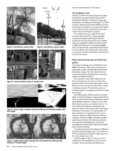
                                                                             Two video recordings were available from two
                                                                             different locations. They were used to create
                                                                             panoramic images with aircraft positions and
                                                                             video time stamps. The video distortion was
                                                                             corrected using the dedicated lens correction
                                                                             profile (see Figures 4 and 5).
                                                                               The resolution of the video influences the
        Figure 6. Camera location shown in Google Earth.                     data reconstruction accuracy as well as the
                                                                             precision of the time stamp information. Video
                                                                             frames at every second were selected to ensure
                                                                             maximum accuracy. The security camera re-
                                                                             cording frequency was approximately one frame
                                                                             per second.
                                                                               The GPS location of both cameras was iden-
                                                                             tified, as shown in Figure 6, using Google Street
                                                                             View, as well as the location of reference objects
                                                                             like buildings and trees, as shown in the video.
                                                                             The location accuracy was defined with +/- 16
                                                                             feet in latitude/longitude and altitude. The
                                                                             reference objects were used to place the image
        Figure 7. Lines of sight of witness statement (left) and reconstructed location with
        error (right).                                                       information within the 3-D environment. All
                                                                             data collected was imported into the recon-
                                                                             struction software called Immersive Witness
                                                                             Analyzer, which sets all lines of sight consider-
                                                                             ing reference objects. The software estimates
                                                                             the reconstructed flight path considering
                                                                             potential error information using the specified
                                                                             and decribed formulas.
                                                                               To estimate the aircraft’s attitude at different
                                                                             locations along the flight path, a 3-D model of a
                                                                             B-767 was placed and adjusted with respect to
                                                                             the video image frame rate.
                                                                               The left image in Figure 7 shows the lines
        Figure 8. Single frame of video showing the B-767 behind trees (left) and with    of sight from the perspectives of two security
        overlay of 3-D object (right).                                       cameras. The intersection of both lines ap-
        10  •   January-March 2021 ISASI Forum
   5   6   7   8   9   10   11   12   13   14   15